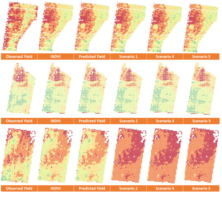
 Exemplar spatial patterns of: combine-mounted yield-monitored data (Observed Yield); iNDVI; model-predicted yield with the entire dataset (Predicted Yield), and under different extrapolation scenarios for Field 1d in 2002 (upper), Field 4b in 2009 (middle), and Field 1h in 2009 (lower). Red represents lowest values and blue highest values.
Abstract
Information on long-term yield variability is important for tailoring farming practices to the needs of crops. We present a linear mixed-effects model to predict wheat yield at a within-field scale in the northern grains-growing region of Australia. The model predicts yield as a function of Landsat time-integrated Normalized Difference Vegetation Index (iNDVI), and is trained on sparsely sampled yield-monitored data from 17 farms from 2001 to 2016. The model is flexibly parameterized, to use information from specific fields, farms or years, to capture local departures from the global yield-iNDVI relation. We estimated iNDVI numerically by integrating the area under a fitted asymmetric bell-shaped growth function, across the growing season (May to October), using NDVI time-series from April to November. We performed leave-one-out cross-validation, where data from individual farms, fields and years were omitted in a series of tests. Results showed moderate predictive accuracy at a within-field scale, with an average RMSE of 0.79 Mg/ha. The spatial pattern of within-field yield variation was adequately represented. The benefit of the mixed-effects model is that, as well as describing the general relation between wheat yield and iNDVI, it explicitly considers the spatial and temporal differences among farms, fields and years, which are related to variations in soil conditions, farm-management practices and climate. The long-term archive of Landsat imagery—combined with a growing archive of yield maps—provides potential for the model to predict yield variation across large regions and many seasons. Such information could help farmers make decisions on site-specific soil and nutrient management, and simultaneously guide policy-makers towards regional development objectives.
Yunru (Chloe) Lai
Research Fellow - Soil and Crop Modelling
My research interests include pedometrics, empirical and mechanistic soil and crop modelling.