Hello!
My research develops practical solutions for spatially explicit, timely, data-driven farm management by modelling the interactions between soil constraints, crop production, and management practices. I specialise in integrating agricultural systems models, machine learning, and geostatistics to understand and connect processes at different scales. I work closely with industry partners to address specific challenges related to soil constraint management.
- Pedometrics
- Geostatistics
- Plant-soil-climate-management interactions
- Soil constraints
- Agricultural systems modelling
PhD in Agricultural Science, 2021
The University of Queensland
Bachelor of Environmental Management, Sustainable Development Major, First Class Honours, 2014
The University of Queensland
Projects
Featured Publications
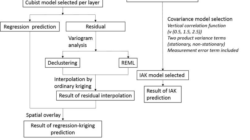
Soil sodicity, generally measured through the exchangeable sodium percentage (ESP), is the most prevalent edaphic stress in Australia, particularly in the northern grains-growing region (NGR) of Australia. Farmers, scientists and policy-makers need accurate maps of sodicity for environmental modelling, and to make rational decisions for management. A common approach to mapping soil properties for multiple target depths is to first harmonize soil profile data to the target depth intervals, usually through equal-area spline functions, then undertake a two-dimensional spatial analysis (often regression kriging) for each interval; we refer to this as a ‘spline-then-krige’ (STK) approach. An alternative is to calibrate a single three-dimensional model that describes soil variation both horizontally and vertically, as is done in the increment-averaged kriging (IAK) approach. This study compares IAK and STK for mapping ESP in the NGR. A machine-learning algorithm was used to model trends based on environmental covariates in both approaches. Both IAK and STK captured the ESP variation reasonably well (concordance correlation coefficient values for IAK around 0.5 for all depths), with IAK giving slightly better predictive accuracies for all depths, most evidently in the topsoil. IAK allows the natural use of all available data, explicitly accounts for the sample support of the soil data and the horizontal and vertical auto-correlation between and within soil profiles, and enables the propagation of uncertainty from the original data through to the final predictions and prediction uncertainties. We conclude that IAK can provide a competitive alternative to STK approaches for mapping soil properties in three dimensions.
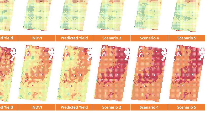
Information on long-term yield variability is important for tailoring farming practices to the needs of crops. We present a linear mixed-effects model to predict wheat yield at a within-field scale in the northern grains-growing region of Australia. The model predicts yield as a function of Landsat time-integrated Normalized Difference Vegetation Index (iNDVI), and is trained on sparsely sampled yield-monitored data from 17 farms from 2001 to 2016. The model is flexibly parameterized, to use information from specific fields, farms or years, to capture local departures from the global yield-iNDVI relation. We estimated iNDVI numerically by integrating the area under a fitted asymmetric bell-shaped growth function, across the growing season (May to October), using NDVI time-series from April to November. We performed leave-one-out cross-validation, where data from individual farms, fields and years were omitted in a series of tests. Results showed moderate predictive accuracy at a within-field scale, with an average RMSE of 0.79 Mg/ha. The spatial pattern of within-field yield variation was adequately represented. The benefit of the mixed-effects model is that, as well as describing the general relation between wheat yield and iNDVI, it explicitly considers the spatial and temporal differences among farms, fields and years, which are related to variations in soil conditions, farm-management practices and climate. The long-term archive of Landsat imagery—combined with a growing archive of yield maps—provides potential for the model to predict yield variation across large regions and many seasons. Such information could help farmers make decisions on site-specific soil and nutrient management, and simultaneously guide policy-makers towards regional development objectives.
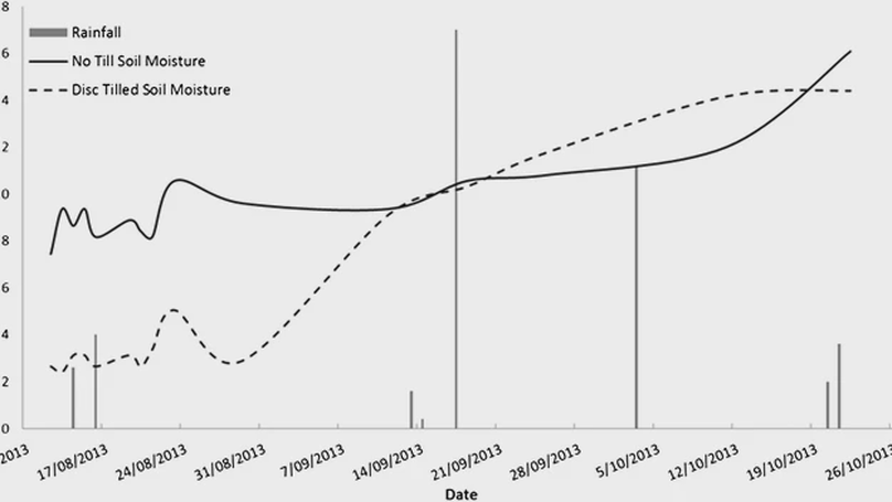
Farmers often resort to an occasional tillage (strategic tillage (ST)) operation to combat constraints of no-tillage (NT) farming systems. There are conflicting reports regarding impacts of ST and a lack of knowledge around when, where and how ST is implemented to maximise its benefits without impacting negatively on soil and environment. We established 14 experiments during 2012–2015 on farms with long-term history of continuous NT to (i) quantify the associated risks and benefits to crop productivity, soil and environmental health and (ii) explore key factors that need to be considered in decisions to implement ST in an otherwise NT system. Results showed that introduction of ST reduced weed populations and improved crop productivity and profitability in the first year after tillage, with no impact in subsequent 4 years. Soil properties were not impacted in Vertosols; however, Sodosols and Dermosols suffered short-term negative soil health impacts (e.g. increased bulk density). A Sodosol and a Dermosol also posed higher risks of runoff and associated loss of nutrients and sediment during intense rainfall after ST. The ST reduced plant available water in the short term, which could result in unreliable sowing opportunities for the following crop especially in semi-arid climate that prevails in north-eastern Australia. The results show that generally, there were no significant differences in crop productivity and soil health between tillage implements and tillage frequencies between ST and NT. The study suggests that ST can be a viable strategy to manage constraints of NT systems, with few short-term soil and environmental costs and some benefits such as short-term farm productivity and profitability and reduced reliance on herbicides.
Recent highlights
Recent & Upcoming Talks
Contact
- Chloe.Lai@usq.edu.au
- +61 7 4631 2332
- T325-2 University of Southern Queensland, West Street, Toowoomba, Queensland 4350
- Monday to Friday 09:00 to 17:00
